
SYLLABUS: Science and Technology General Studies – : III Achievements of Indians in science & technology; indigenization of technology and developing new technology.
IN NEWS: Why is the NVS-03 satellite launch significant?
QUESTION: What is NavIC, and how does it contribute to India’s strategic autonomy? Examine the challenges involved in ensuring the reliability of an indigenous satellite navigation system. (15 marks, 250 words)
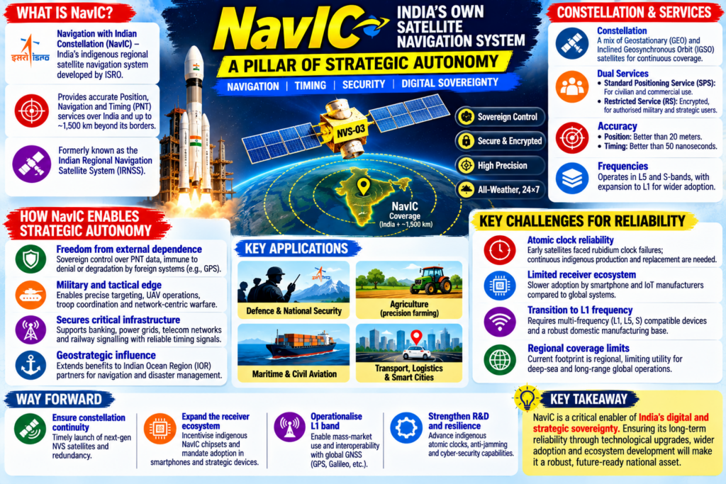
ANSWER: NavIC (Navigation with Indian Constellation), formerly known as the Indian Regional Navigation Satellite System (IRNSS), is an autonomous regional satellite navigation system developed by the Indian Space Research Organisation (ISRO). Designed to provide accurate real-time position and timing information, NavIC covers India and a primary service area extending up to 1,500 km beyond its borders, establishing an indigenous anchor for national security and digital infrastructure.
1. Architecture and Core Capabilities of NavIC
- Constellation Design: NavIC relies on a constellation of operational satellites positioned in a strategic mix of Geostationary Earth Orbit (GEO) and Inclined Geosynchronous Orbit (IGSO) slots, ensuring continuous visibility over the Indian landmass.
- Dual Services:
- Standard Positioning Service (SPS): Provided to civilian users for commercial applications, location-based tracking, and mapping.
- Restricted Service (RS): An encrypted service restricted exclusively to authorized strategic and military users for high-precision operations.
- High Precision: NavIC operates across multiple frequency bands (primarily L5 and S-bands) and offers positional accuracy of better than 20 meters and timing accuracy of better than 50 nanoseconds, outperforming single-frequency foreign systems in its coverage zone.
2. Contribution to India’s Strategic Autonomy
- Elimination of Strategic Dependency: Reliance on foreign Global Navigation Satellite Systems (GNSS)—such as the US GPS or Russian GLONASS—poses national security vulnerabilities during armed conflicts or geopolitical standoffs, where access could be deliberately degraded, denied, or filtered. NavIC ensures absolute sovereign control over critical positioning data.
- Military and Tactical Superiority: The encrypted Restricted Service provides the backbone for India’s modern defense architecture, enabling precise targeting for cruise and ballistic missiles, uncrewed aerial vehicles (UAVs), infantry troop coordination, and network-centric warfare.
- Securing Critical National Infrastructure: Critical sectors such as financial transactions, power grid synchronization, telecom networks, and railway signaling require ultra-precise timing signals. NavIC insulates these foundational nodes from foreign cyber-espionage and external systemic disruptions.
- Geostrategic Influence in the Indian Ocean Region (IOR): By extending its footprint 1,500 km beyond borders, NavIC enables India to project technological leadership and act as a net security provider, assisting friendly maritime neighbors in navigation and disaster management.
3. Challenges in Ensuring System Reliability
- Atomic Clock Failures and Constellation Maintenance: Early generations of NavIC satellites faced premature failures of imported Rubidium atomic clocks, which are vital for maintaining microsecond timing accuracy. Although ISRO has successfully tested and deployed indigenous rubidium atomic clocks in newer NVS-series satellites, continuous replenishment remains capital-intensive.
- Underdeveloped Domestic Receiver Ecosystem: Commercial adoption has historically lagged because mainstream smartphone manufacturers and IoT device makers were slow to adopt NavIC chipsets, primarily due to the lack of a standardized global ecosystem compared to GPS.
- The Transition to L1 Frequency: To achieve mass commercial acceptance and seamless interoperability with global systems, NavIC must transition to the civilian-friendly L1 frequency band. Integrating L1, L5, and S-bands into multi-frequency receiver hardware requires extensive domestic manufacturing and design capabilities.
- Regional Limitations vs. Global Reach: Unlike GPS or Galileo, which provide global coverage, NavIC is structurally constrained to a regional footprint. This limits its utility for deep-sea blue-water naval operations or long-range strategic assets operating outside the Indian subcontinent’s periphery.
NavIC represents a critical pillar of Atmanirbhar Bharat in high-technology aerospace domains, shielding India’s military and civil infrastructure from external dependencies. Ensuring its long-term reliability requires accelerating the deployment of the next-generation NVS satellites, expanding the L1 frequency band ecosystem, and enforcing statutory mandates for device manufacturers to build NavIC-native hardware.
|
SOURCE: The Hindu epaper – Why is the NVS-03 satellite launch significant?