
|
IN NEWS: Nepal disaster, a grim reminder to rethink preparedness
QUESTION: Recent Himalayan disasters have exposed vulnerabilities in India’s preparedness for cascading and multi-hazard events. Examine the major gaps in India’s Himalayan disaster management framework and suggest measures to build a more anticipatory and climate-resilient system. (15 marks)
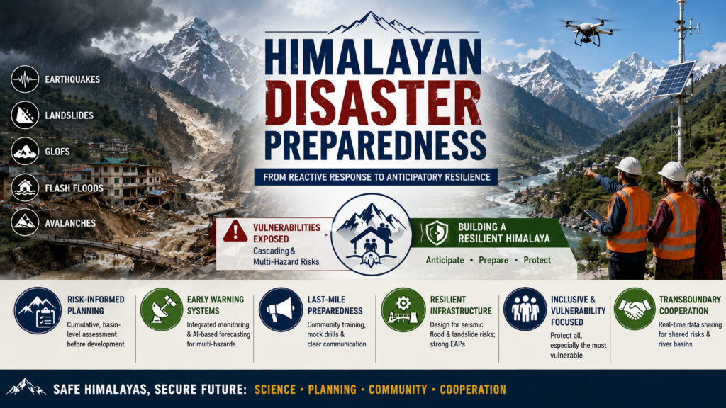
ANSWER: The Himalayas are a young, tectonically active and geomorphologically fragile mountain system, comprising the Greater, Lesser and Shiwalik Himalayas. Their steep slopes, active faults, glaciers and fragile lithology make them susceptible to earthquakes, landslides, GLOFs, flash floods and avalanches. Climate change and infrastructure expansion are increasingly converting these individual hazards into cascading disasters.
Why is Himalayan disaster risk becoming cascading?
- Geographical fragility:
The Greater Himalayas contain extensive glaciers and glacial lakes, while the Lesser Himalayas have unstable slopes and weaker rock formations. The Shiwaliks, with relatively unconsolidated sediments, can transmit large volumes of debris and floodwater towards the plains. - Climate-induced amplification: Glacier retreat, permafrost degradation, glacial-lake expansion and extreme precipitation are increasing the probability of GLOFs, ice-rock avalanches, landslides and flash floods.
- Infrastructure-induced vulnerability: Roads, tunnels, hydropower projects and urban expansion in narrow valleys can involve blasting, slope cutting, excavation and muck dumping, disturbing natural drainage and slope stability. Such interventions may act as risk multipliers, particularly when cumulative impacts are ignored.
Thus, an earthquake, extreme rainfall or glacier/rock avalanche can initiate a chain of slope failure → river blockage → sudden flood → debris flow → damage to infrastructure and settlements.
Existing policy and institutional framework
India has a substantial disaster-risk architecture:
- Disaster Management Act, 2005: Provides the institutional framework through NDMA, SDMAs, DDMAs and NDRF.
- National Disaster Management Plan (NDMP): Aligns India’s disaster management approach with the Sendai Framework, emphasising prevention, mitigation, preparedness, response and recovery.
- Dam Safety Act, 2021: Provides a statutory framework for surveillance, inspection and safety of specified dams.
- National GLOF Risk Mitigation Project: Focuses on GLOF hazard assessment, monitoring, early warning, mitigation and community preparedness in vulnerable Himalayan States.
- National Landslide Risk Management Strategy, 2019: Provides a framework for landslide hazard mapping, vulnerability assessment, early warning, awareness and capacity building.
- National Mission for Sustaining the Himalayan Ecosystem (NMSHE): Promotes scientific understanding and conservation of the Himalayan ecosystem.
- SACHET and Common Alerting Protocol: Provide a platform for disseminating geo-targeted disaster warnings.
- National Centre for Seismology, IMD, CWC, GSI and ISRO: Together provide monitoring, forecasting, hazard mapping and geospatial decision support.
Major gaps in the existing framework
- Fragmented rather than cascading-risk management:
Institutional responsibilities remain largely hazard-specific, whereas Himalayan disasters increasingly involve interactions between geological, hydrological and cryospheric processes. - Project-level rather than landscape-level assessment:
EIA and clearances can focus on individual projects, while the cumulative consequences of multiple dams, tunnels, roads and settlements within a river basin may remain inadequately assessed. - Development–ecology mismatch:
Infrastructure planning does not always sufficiently integrate carrying capacity, seismic vulnerability, slope stability, GLOF risk and future climate scenarios. - Science-to-action gap:
India’s forecasting capabilities have improved, but the effectiveness of an early warning ultimately depends upon last-mile communication, evacuation capacity and community preparedness. - Existing infrastructure can become secondary hazards:
Damage to dams, bridges, roads and tunnels can amplify the consequences of the original natural hazard, requiring critical-infrastructure risk assessment and emergency action planning. - Transboundary governance:
The Himalayan cryosphere and river systems transcend political boundaries. Weak real-time sharing of glacial, meteorological and hydrological information can increase downstream vulnerability. - Social vulnerability:
Women, children, elderly persons, persons with disabilities and remote mountain communities may face greater difficulties in evacuation, communication, relief access and post-disaster recovery. Disaster planning therefore needs a gender- and vulnerability-responsive approach.
Way Forward: From disaster response to anticipatory resilience
- Risk-informed infrastructure planning:
Move from isolated project appraisal towards cumulative, basin-wide and landscape-level assessment. Major infrastructure should incorporate seismic, landslide, GLOF, flood and climate-risk assessments from the design stage. - Strengthen Himalayan carrying-capacity assessment:
Assess the combined pressure of hydropower, roads, tourism, settlements and ecological degradation before permitting additional infrastructure in vulnerable valleys. - Adopt a mitigation hierarchy:
Where risks are excessive, prioritise avoidance and redesign, followed by engineering mitigation and, where necessary, relocation. Run-of-river and pumped-storage options can be considered where they reduce risks associated with large reservoirs, subject to site-specific ecological and geological assessment. - Build a genuinely multi-hazard early-warning system:
Integrate IMD, CWC, GSI, ISRO, NCS and State agencies through a common risk-information architecture. Expand remote sensing, InSAR, automatic weather stations, hydrological sensors, glacier monitoring and AI-based forecasting. - Close the last-mile gap:
Convert warnings into action through village-level hazard maps, evacuation routes, shelters, mock drills, trained local volunteers and multilingual alerts. Disaster plans should specifically identify vulnerable groups and their evacuation and relief requirements. - Climate-resilient critical infrastructure:
Regularly audit existing dams, tunnels, roads and bridges for compound hazards, strengthen drainage and slope stabilisation, and ensure effective Emergency Action Plans and dam-break preparedness. - Strengthen transboundary cooperation:
Develop mechanisms with Nepal, Bhutan and China for real-time sharing of river discharge, rainfall, seismic, glacier and GLOF information, particularly for shared river basins.
The Himalayan challenge is not merely to predict an earthquake, GLOF or landslide, but to prevent one hazard from cascading into a larger disaster. India must therefore move from hazard-specific and project-centric management towards cumulative, basin-level and anticipatory risk governance. Development in the Himalayas should follow the principle of risk-informed development, balancing infrastructure needs with ecological carrying capacity, climate resilience and the safety of vulnerable communities.
|
SOURCE: The Hindu e-paper – Nepal’s agony, the Himalayan warning to India